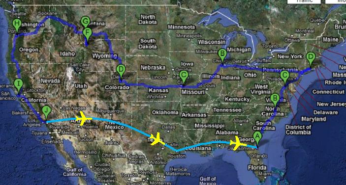
Journey Map

Journey Map
4,600 miles West

Wednesday, August 25, 2010

Day 11 - The final leg

The final leg of our journey was fortunately the shortest drive – 6 hours!  Thank goodness!  We were eager to get there...


so we decided this time that we would take the quicker route down highway 5 straight to our destination outside of Los Angeles – Upland.


The landscape made a drastic change from green, lush trees, to brown, dry hills (not to mention it was about 10 degrees warmer only 10 minutes outside of the bay area).


Coast Ranges
But as we got closer to LA, we approached the San Gabriel Mountains (Mount Baldy) which were greener and much bigger.


We reached our final destination of Upland, a California suburban town, just in time for dinner.


Welcome Home CJ!
 

Day 10 - Sittin on the dock of the Bay

Unfortunately our friend Jen had to work the next day so we were on our own to tour the city.  With no preconceived notions of what to expect, we relied heavily on tips from her lovely roommates, as well as advice from the book entitled “Broke-Ass Stuarts Guide to Cheap Living in San Francisco”.  After one day in his hands, we knew tidbits of information about almost every neighborhood in San Fran, especially the Mission.  


We spent our time enjoying sights like the renowned trolleys 


the bay


 Fisherman’s Wharf  


                          a fish bike


and to go with these......


a giant heart shaped crab


and


crab shaped bread


 an angry mob of Segways (the most violent gang in San Fran).


Island of the Pelicans
Alcatraz -  the remote island offshore in San Fran which served as a US federal prison for 29 years.  The name was taken from the first documentation of its name translated to "Island of the Pelicans" - pelicans being the archaic Spanish word "Alcatraz".


Silly Seals 


The Golden Gate bridge embraced by clouds

Golden Gate Bridge

At the top (hard to see)


The crookedest street (from afar) on Lombard Street


and of course (CJ’s favorite) – Chinatown.  Apparently San Fran’s Chinatown is the oldest in North America, and the largest...outside Asia of course.
 

We followed Grant Ave all the way through to the bottom of Chinatown and finished on Mission Street where we took to our final destination – free oysters (for CJ), and cheap draft beer (for me…and CJ).


This hidden gem was recommended by broke-ass Stuart and comes highly recommended by us – El Rio 


We met up with some friends of mine from London for a 1 year reunion (literally, 1 year on the dot).  We also had the good luck of meeting up with a friend we grew up with in Maine for a 10 year reunion – it was how broke-ass Stuart said it would be, “a blast from the past”.  Good times were had all around, but unfortunately no pictures to document it.

San Francisco was one of our favorite spots and we’ll be back again for a much longer visit!

Day 9 – Down the Pacific Coast

Before commencing our travels south, we made a very important stop in Portland.  We stopped at an establishment known as “Voodoo Doughnut” which might possibly have the most variety of donut options of any donut place to ever exist. 

CJ indulged in their famous “Maple Bacon Bar” and I treated myself to their very large apple fritter (which unfortunately I was unable to finish since it was literally the size of my face).


Fear not oh faithful vegans for they have an array of vegan donut options as well!  Clearly they have something for everyone!


After breakfast, we made our way south into sunny California.  We celebrated the occasion by stopping off at the “Jerky Drive-Up”.


 I did not partake in the jerky festivities but CJ enjoyed the delights of this novelty – Cali is his home now, so he’s getting a feel for this strange and foreign culture.


After the jerky stop we continued on our way to San Fran.  We opted for the more scenic route instead of the quicker one.  The scenic route – Route 101 / Redwood Highway – took us through the Redwood Forest and along the Northern Pacific coast.  It was a feast for the eyes!  

 Massive trees towering over our seemingly ant sized space dragon. 


Then peering out to the open waters of the Pacific Ocean 


only to occasionally curve back into the forest catching glimpses of the bright blue waters through the trees 


and sometimes losing all visibility to a cloud passing over the ocean and to the forest.


We came across some interesting sights on the way down – such as a doll's head fastened to the back of a pick-up truck's latch. (This was actually back in Oregon but too good not to share).


There was also the “Legend of Bigfoot” emporium


an actual house inside a tree 


a drive thru tree in Leggett, CA 


and a tree stump I could stand up inside 


The drive continued along windy roads going up and down the sides of mountains all the way to the bay.  Night fell and we still had a few hours left of driving.  We arrived at our destination just outside San Fran in the lovely town of Berkeley, California at 11:00 p.m. at a fellow London / Mountbatten alumnus’ humble abode.  Thanks Jen!

Tuesday, August 24, 2010

Day 8 - All along the Columbia River

From Bozeman we made our final journey west before dropping south towards San Francisco and LA.  We had a long journey ahead of us, a good 12 hours of solid driving accompanied with the extra hour for pit stops and breaks to refuel the space dragon.  The drive, although long and tiring behind the wheel, was beautiful and satisfying.  We traveled along the Columbia River, which splits most of the northern border of Oregon from Washington state, and is actually the largest river in the Pacific Northwest (of North America) clocking at over 1,200 miles long!

But before hitting the Columbia River, we still had the rest of Montana to drive through, along with the 70 mile northern tip of Idaho, and the Southwest corner of Washington.  The remainder of Montana was not dissimilar to the rest of it - however it became much greener as we approached the Idaho border. 

An accurate description of Idaho is "forests galore".  I hadn't seen this many trees so closely packed together since Pennsylvania.  It was refreshing - the west coast was not all dry lands after all.

I may have spoken too soon - Washington was vastly different and most of the western corner seemed pretty dry and vacant.

 I don't want to discredit the state, though, because we did pass through areas where there were some foliage and small bodies of water.


But alas, it was not until we reached Portland that we really saw some scenery.


The Columbia river was pretty massive, and for 3/4 of the border between Oregon and Washington, you must cross over the river.  It almost gave the impression that we were leaving the mainland and headed towards an island.

Approaching the Oregon border
Of course this was not the case and in fact, we still had several hours left before we hit Portland.  But I would not have changed routes for an earlier arrival time.  The drive along the Columbia River was well worth it, as these pictures clearly portray.

Space dragon cruising along
Columbia Gorge
Admiring the view

Washington's mountains and Oregon's cliffs border the Columbia River creating a wind tunnel perfect for wind surfing and kite surfing.

Washington's mountains with wind surfers in the river

Oregon's cliffs
Before ending our trip, we were fortunate enough [again] to witness another glorious sunset behind the mountain tops...and not just any mountain top, but the top of Mount Hood - part of the Cascade Volcanic Arc and the highest mountain in Oregon, peaking at over 11,000 feet.


That helped us enjoy the remainder of our journey into Portland.  Unfortunately this meant that it was dark and so we weren't able to see the city skyline as we approached.  But we did see some pretty lights coming in!

What up Strom! - Portland lights!